Log in
All resources
Create a design
2,977 Free Artworks of City Map
bibliothèque nationale de france
baroque
paper
copper engraving print
matthäus merian
british museum
maps in the library of congress
asia noviter delineata
willem blaeu
maps in the british museum
lawrence h. slaughter collection of english maps, charts, globes, books and atlases
pre-raphaelite brotherhood
maps of cagliari by braun & hogenberg
maps of valletta by braun & hogenberg
maps of coimbra by braun & hogenberg
1598 engravings
manual of the corporation of the city of new york (1857)
1857 books
petit atlas pittoresque des 48 quartiers de la ville de paris, bhvp
paris former 4e arrondissement
petit atlas pittoresque des 48 quartiers de la ville de paris, bhvp
paris former 4e arrondissement
prints in the stadsarchief amsterdam
jan roodenpoortstoren
maps of paris from paris musées
dheulland map of paris
atlas van loon
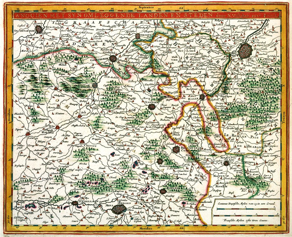
fort-mardyck
1762 maps of north america
maps by tomas lopez
maps of enns by braun & hogenberg
colored copperplate engraving
john rocque 1746 crops from library of congress
maps in the library of congress
print room of the university of antwerp
kaarten van vlaanderen (prentenkabinet)
maps from traité de la police, bibliothèque nationale de france
first map of paris from traité de la police
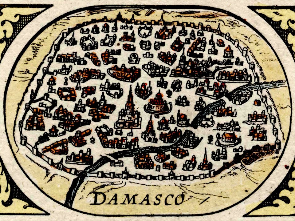
maps of damascus by braun & hogenberg
asia noviter delineata
historical images of macau
asia noviter delineata
french-language maps
ambroise tardieu
turgot map of paris, university of wisconsin-milwaukee libraries
sheet 7 of the turgot map of paris
flandria illustrata
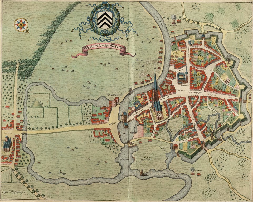
old maps of menen
maps of metz city walls
old maps of metz
prints by mario cartaro
old maps of jerusalem
maps in the staats- und universitätsbibliothek hamburg
1870 maps of hamburg
anthonis van den wijngaerde
historical images of lleida
1852 maps of france
old maps of isère
map of maastricht by willem and johannes blaeu (1649)
history of wyck (maastricht)
print room of the university of antwerp
18th-century maps of antwerp
engravings of topographia saxoniae inferioris
baroque
civitates orbis terrarum. de praecipuis totius universi urbibus. liber secundus
maps of dunkerque by braun & hogenberg
civitates orbis terrarum. de praecipuis totius universi urbibus. liber secundus
maps of tunis by braun & hogenberg
civitates orbis terrarum. de praecipuis totius universi urbibus. liber secundus
maps of šibenik by braun & hogenberg
sanborn maps of manhattan published in 1904
irt sixth avenue line stations
plans of castles of japan
hyogo castle
bibliothèque nationale de france
maps by tomas lopez
maps by juan lopez
1835 maps of spain
flandria illustrata
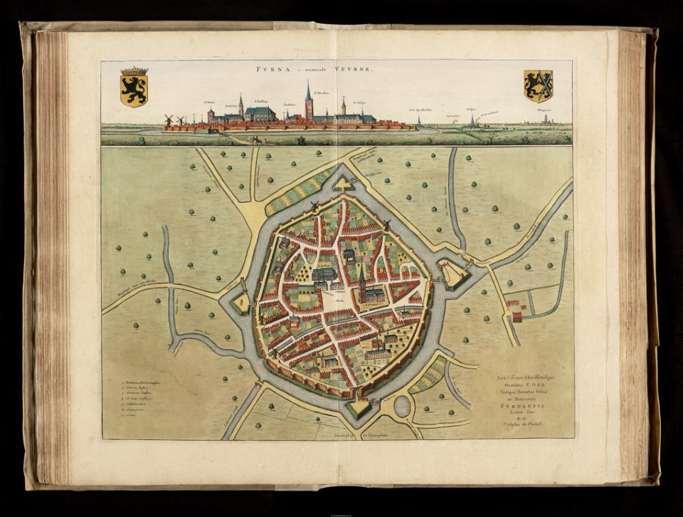
history of veurne
maps by willem and johannes blaeu
fort-mardyck
potsdam in the 1770s
old maps of potsdam
asia noviter delineata
history of banten
manual of the corporation of the city of new york (1862)
maps from valentine's manual
maps by john cary
1801 maps
atlas van der hagen (volume 2)
atlas van der hagen
parts of old maps of hamburg
maps of hamburg-sternschanze
maps of mexico city by braun & hogenberg
maps of cusco by braun & hogenberg
east prospect of the city of philadelphia
independence hall in art
maps by pieter mortier
maps from gallica
maps in the library of congress
1785 maps
maps of 's-hertogenbosch by braun & hogenberg
maps of leuven by braun & hogenberg
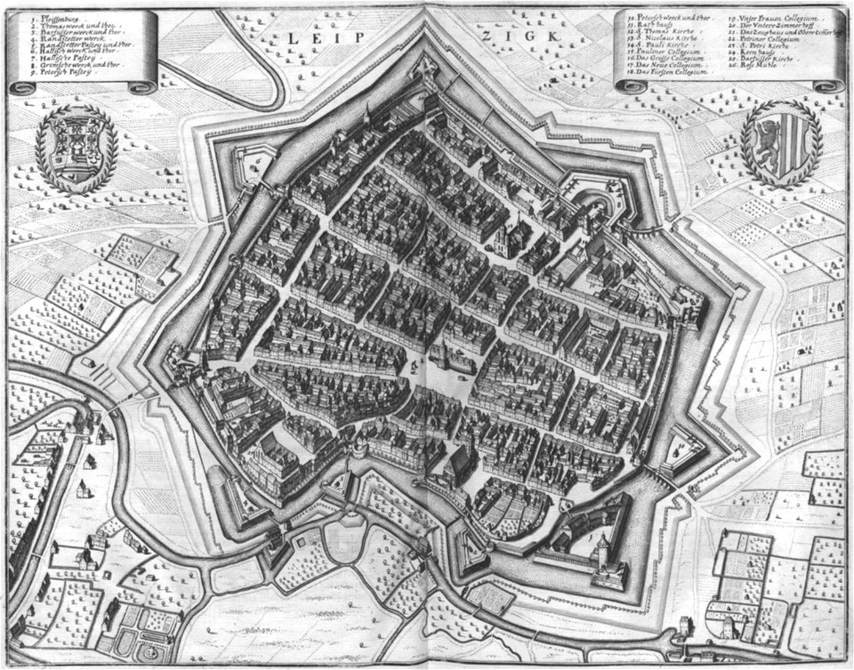
19th-century maps of dresden
vogelsches gartenhaus
maps of arnsberg by braun & hogenberg
history of arnsberg
maps of bremen by braun & hogenberg
maps of stade by braun & hogenberg
maps in the british museum
maps by john speed
topographia westphaliae (merian)
baroque
maps by bernard ratzer
maps by thomas kitchin
maps of london by braun & hogenberg
maps in the british museum
maps of london by braun & hogenberg
maps in the british museum
jerusalem in 17th-century art
asia noviter delineata
plan de la ville et faubourg de paris, divisé en ses 48 sections by mondhare & jean
maps of paris from the stanford libraries
prints of cartouches in the rijksmuseum amsterdam
maps in the rijksmuseum amsterdam
engravings of topographia saxoniae inferioris
baroque
media from the national library of finland
classicism
maps of groningen by braun & hogenberg
history of martinikerk (groningen)
eran laor cartographic collection
pierre aveline
old maps of liège (city)
fort de la chartreuse
maps of barcelona by braun & hogenberg
1645 in andalusia
goetheplatz (frankfurt)
an der hauptwache
friedrichswerdersche kirche
johann david schleuen
maps from university of amsterdam special collections
atlas der neederlanden
maps from university of amsterdam special collections
atlas der neederlanden
16th-century maps of amsterdam
maps by jacob van deventer
maps of mexico by mercator-hondius
maps of philippeville by braun & hogenberg
maps of mariembourg by braun & hogenberg
1572 maps of africa
1570s maps of egypt
maps of salzburg by braun & hogenberg
maps of ulm by braun & hogenberg
bern city map of 1638 by matthäus merian
baroque
old maps of china in harvard map collection
1749 maps of asia
engravings of topographia braunschweig lüneburg
baroque
old maps of amsterdam
evert maaskamp
engravings of topographia saxoniae inferioris
baroque
curt teich postcard archives
king city, missouri
maps of bergamo city walls
maps in the museo correr
atlas schoemaker-noord-holland, amsterdam
old maps of diemen
atlas schoemaker-noord-holland, amsterdam
old maps of amsterdam
maps in the library of congress
birds-eye view of seattle, 1884
maps by willem and johannes blaeu
old maps of groningen (city)
bruxella nobilissima brabantiae civitas an° 1640
port of brussels
maps in the library of congress
old maps of new jersey
panoramic maps of seville by braun & hogenberg
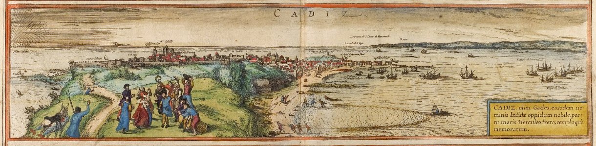
maps of cadiz by braun & hogenberg
lawrence h. slaughter collection of english maps, charts, globes, books and atlases
nypl lionel pincus and princess firyal map division
alessandro baratta
old maps of genoa
amérique méridionale (1748, d'anville)
rococo
curt teich postcard archives
postcards of oklahoma city
historical images of abbaye de saint-germain-des-prés
foire saint-germain on old maps
cities in spain in the 16th century
maps of cadiz by braun & hogenberg
engravings of topographia superioris saxoniae, thüringiae, misniae et lusatiae (merian)
baroque
maps of neuf-brisach city walls
leonhard christoph sturm
maps by pieter mortier
old maps of rovigo
maps of genoa by braun & hogenberg
maps in the british museum
maps of frankfurt (oder) by braun & hogenberg
maps of wittenberg by braun & hogenberg
old maps of oudenaarde
flandria illustrata
prints by wenzel hollar in the british museum
prints in the british museum
801 - 900 of 2,977
Next page
/ 30